Microbes, like bacteria and fungi, are all around us — in the air, in the water, in our bodies and more. There are millions of types, all occurring in different environments, with more species being discovered every day.
The Cockrell School of Engineering’s Department of Civil, Architectural and Environmental Engineering has partnered with several groups to discover which microbes are found across the UT Austin campus, combining a variety of expertise to gather and explain the findings.
The UT Biome Project, led by Cockrell School professor Kerry Kinney, uses the Forty Acres as a “living” laboratory to collect environmental data and map the communities of microbes living in the air and water around us.
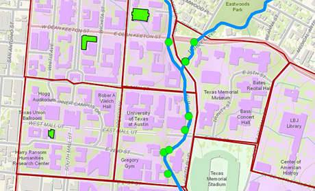
Since it would be virtually impossible to accurately map the entire biome of campus — it would involve taking samples from literally every inch — the project focuses on certain sites around the university and displays the data in an interactive online map.
For the past two semesters, Kinney’s engineering students have left the classroom for the field to get a hands-on introduction to environmental engineering, collecting water samples from different parts of Waller Creek and air samples from campus buildings.
“The students get so excited about this project,” Kinney said. “It’s a way to take something that’s being taught theoretically in the class and make it very real — and because it’s open data, it gets the whole community involved.”
Collecting the Data
For many of the students in the course, this was their first time gathering samples in the field.
“I never thought so many things would happen in such a small creek of water,” said senior Jordan Alvarez. “After you conduct an experiment like this, you feel very attached to the results, and you want to learn and find out more.”
Throughout the semester, students learned how to use sampling technology and field sampling techniques. Working with environmental engineering postdoctoral researcher Juan Pedro Maestre, who recorded the group’s progress through a blog and Twitter, the students also live-tweeted their sampling results.
The samples were sent to the Genomic Sequencing and Analysis Facility on campus where the microbes’ DNA was sequenced to identify the types and relative abundance of the microbes in each sample. The students also collected additional environmental information about the samples, such as pH and dissolved oxygen concentration, and they processed this information to accompany the sequencing data on the interactive map. Each sample kit contained a QR code, which students scanned with their smartphones so that, using GPS and geographic information system (GIS) technologies, the data they entered for that location would be attached to the map.
“I didn't expect to be involved in a sampling project in the introductory environmental engineering class, and it was actually a lot more fun than I expected,” said senior Emily Tat. “It's one thing to learn about a topic in class; it’s another thing to see it in the field.”
Creating the Platform
In order to communicate the findings, the project’s interactive map will include several layers of information.
The first layer will be intended for the general public and will explain the meaning behind the data for each location in simple terms. The second layer will include sequencing data for researchers and other interested groups to explore.
 Civil engineering professor Paola Passalacqua and Ph.D. student Harish Sangireddy have been working to create an interactive map that will translate the technical research and have lasting value. “You can collect all the data you want, but if you don’t communicate it to the public, then the project becomes kind of pointless,” Passalacqua said.
Because the data includes microbes such as bacteria and fungi, which could concern the general public, the UT Biome Project team saw a need to clearly communicate information about the findings.
“People are living and working in an organic and dynamic world that has elements or organisms that are potentially harmful to them,” said School of Nursing professor Sharon Horner. “Nursing's contribution will be a vital one in terms of interpreting the findings for the non-researcher and making recommendations to keep people safe and healthy.”
Currently, the UT Biome Project leaders are updating and adding sampling and sequencing data to the interactive online map. Looking forward, the UT Biome team hopes to collaborate with other universities and groups pursuing environmental, sustainability, and energy research.
Additional participants in the UT Biome Project include: Mary Jo Kirisits, Lynn Katz, Navid Saleh, Atila Novoselac, and chair Richard Corsi from the Department of Civil, Architectural and Environmental Engineering; Jay Banner and Eric Hersh from the Environmental Science Institute; and Christine Hawkes from the College of Natural Science’s Department of Integrative Biology.
In 2013-14, the UT Biome Project received funding from the Longhorn Innovation Fund for Technology (LIFT). This fund provides seed funding to UT Austin projects that use information technology to improve quality of instruction and address campus needs.


